A re-examination of the Waverley Line has led me to believe that this alignment could be more precise if I abandoned the notion that Point 251/7 at Merrow Church had to be exactly coincidental to Point 132/4, also at Merrow Church but on the crossing of the Newlands Line. I had stuck to this idea because both points have a remarkable accuracy with the Druid Mile (DM), Point 132/4 being four DM on the 132 degree line from the base point of Whitmoor Barrow, and 251/7 being three DM from East Clandon Church. A plan of this church from a local history website shows the outline of the original eleventh century building. If the centre of this structure is taken as the revised start to the alignment (nothing is currently found to the east) and the termination is taken as the centre of the Monk’s Choir within the nave of Waverley Abbey, then the accuracy of the alignment through six points becomes astonishingly precise. There is a slight change in the angle from grid north at 251.50 degrees to 251.53. This has the effect of moving the line from just outside the buildings of East Clandon Church and Merrow Church to the centre of the structures. I have redrawn the site plans of these six points and revised the respective overall plan and data sheet.
The original numbering of this line was to take in the Churches of West Horsley, 251/1 is just beyond to the East, and West Clandon between Points 251/5 and 251/6, but neither of these churches is close enough to the alignment, West Horsley being 30 metres to the south and West Clandon is 45 metres to the north. It is thought that the rough alignment of these churches is because the hamlets they serve were established upon the spring line of waters issuing from the interface of local clay and the chalk hills to the south.
The orientation of these sites may be of interest; East Clandon at 256.4 degrees is five degrees from the orientation of the line; Merrow Church at 260 degrees is 8.5 degrees, and Guildford Friary at 255.5 is four degrees. Grid west is 270 degrees so all these sites are some ten to fifteen degrees anti-clockwise from true west and much closer to the orientation of the line. Waverley Abbey bucks the trend by being thirteen degrees north of due west.
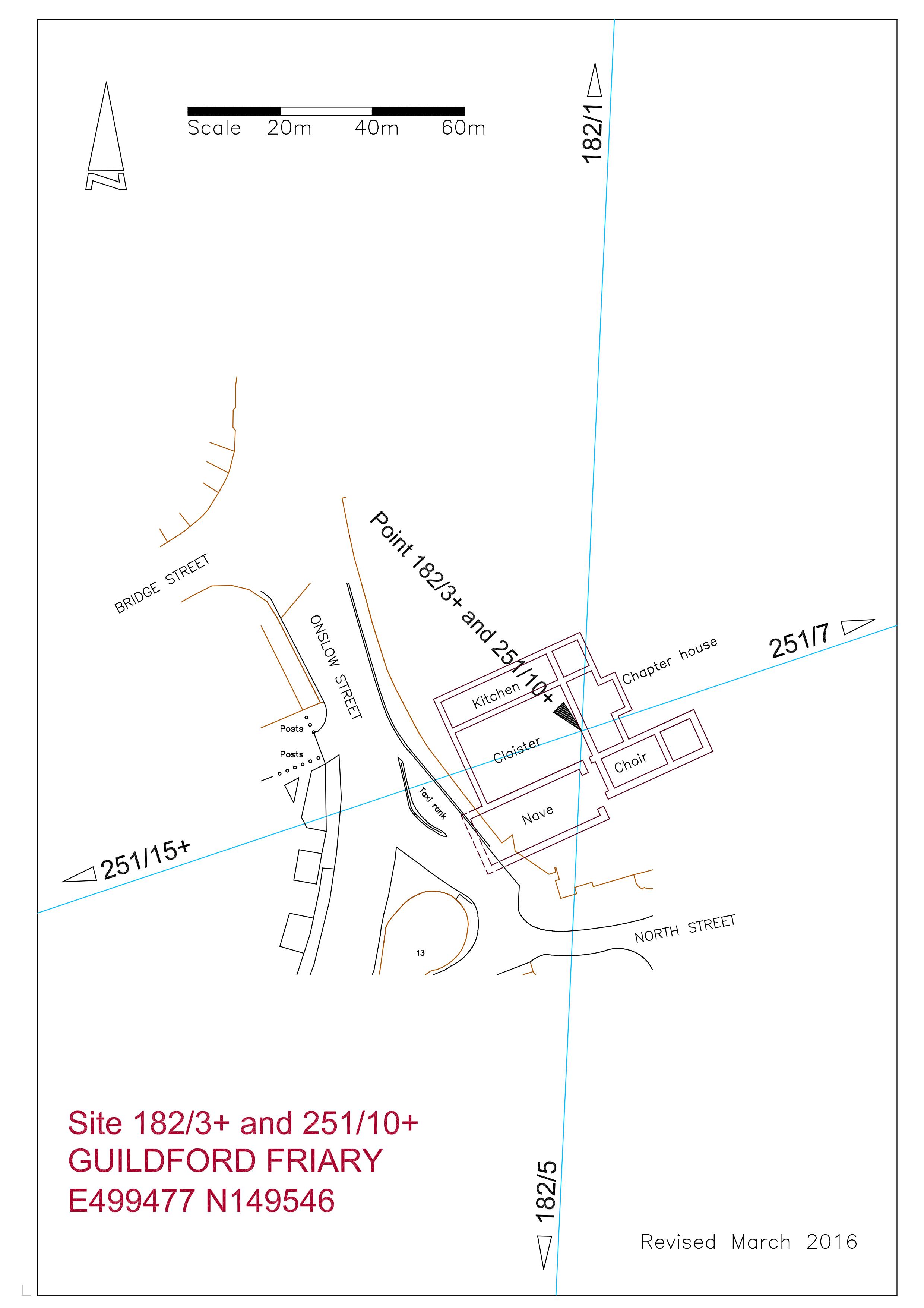
It has always been interesting to me that the site is on the South Line, being the central spine of the ten degree alignments, but the actual location of the friary is poorly defined on the Ordnance Survey, shown only as a comment “Site of friary founded 1275′, therefore the accuracy of any alignment has been unverified, but I have now obtained a copy of the “Research Volume of the Surrey Archaeological Society No 9′ titled “Excavations on the Site of the Dominican Friary at Guildford in 1974 and 1978, by Rob Poulton and Humphrey Woods, published by the SAS in 1984. By today’s standards the location plan is not brilliant, being more of a sketch than a survey, but with enough information to allow me to enlarge it to 1-200 scale enabling the measurement of the discovered foundations and adjoining streets to be transferred into AutoCAD. This digital drawing was overlaid on my OS database as a block and adjusted to obtain a best fit with the neighbouring streets. The report also included an aerial photograph of the excavated site which I have used to further enhance the fit, and I now feel that I have the position of the friary buildings to within perhaps three metres of accuracy.
The area of demolition of the old Friary Meux Brewery to facilitate the construction of the Friary Centre shopping mall covers a large area and the excavated foundations take up perhaps about fifteen per cent at the most. Therefore I was surprised to see that the two alignments passing through the site crossed within the excavated structure, with the South Line passing through the nave at the choir end (see plan). Once again I am impressed with the coincidence of my findings. Only the west end of the nave remains unexcavated as it lies just within the roadway of Onslow Street and maybe one day it will be possible to reveal this to accurately survey the location of the complex. The revision to the line brings it nearer the centre of the excavated foundations.

The fourth point is Frowsbury Barrow standing next to a fairway of Puttenham Golf Club and is easily accessed from the Pilgrim’s Way long distance footpath just to the north. The code for this site is 251/15+, the plus sign showing that it is more than 15 DM along the line from the base point. It is 41 metres across with a ditch bringing the overall width to 47.5 metres, and is 2.4m high. In 1857 Queen Victoria reviewed her troops from the top and this is commemorated by a stone tablet and a flagpole. The line passes well within the top of the barrow just south of the flagpole. The barrow is indistinct on natural raised ground and is only obvious when viewed from the south across a fairway. There is a large greenkeepers shed close to the north side which seems to be built in a shallow quarry. There are pine trees between the shed and the barrow but the top of the mound is grassy with some bracken and heather to the east side. Where the surface is exposed it is very sandy.
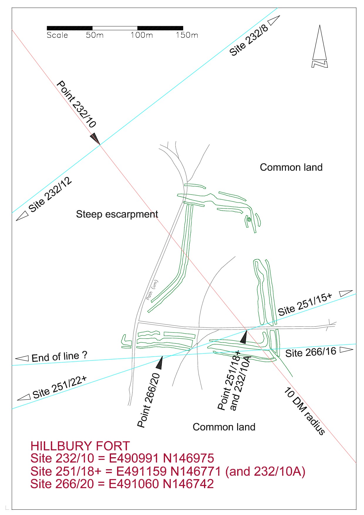
Hillbury Hillfort on Puttenham Common is the fourth point and although this covers a large area Point 251/18+ is positioned on the highest location within the ramparts. This position being determined by the crossing of Line 293, the Frowsbury line, to Compton Church in the south east and Hogs Back Barrow to the north west. This point is precisely ten DM from the base point at Whitmoor Barrow. Line 266, the Deerleap Line, also passes through this point at 20 DM from Deerleap Barrow.
This photograph is taken from near the top of the site looking north across the fort to the Hogs Back on the horizon.
The sixth and currently final site on this alignment is at Waverley Abbey. As with Guildford Friary I originally did not know where the line would fall within the site and it wasn’t until I found a ground plan of the structures that the pieces fell into place with startling accuracy.

The above plan shows the end of the line to be in the centre of the Monk;s Choir at the east end of the nave.
In summary, we have six sites in extremely precise alignment; multiples of the Druid Mile with intersections with other lines; and coinciding orientation of three churches suggesting a possible astronomical alignment. I would need a lot of convincing that this is all coincidence, especially as I cannot at the moment discover any even vaguely similar findings outside of this area .
More information on these sites may be found under the respective headings, or will be soon.


